The Heart Trail in Tørring
Embark on this waymarked hiking route of a manageable distance in the town of Tørring and the surrounding wetlands. Along the way, you will pass through the town on the Gudenå river, past lakes and marshland and all the way to the end of the world.
Experience Tørring on foot
Tørring is known as the starting point of the canoe trip on the river Gudenå but offers much more than that. The town is surrounded by distinctive nature, and a short hike east of town is Denmark’s biggest marshland, Uldum Marsh, which is definitely worth a visit on an excursion in nature. On this hike you will walk through town and east towards the open nature area Tørring Fælled.
Where does the route start?
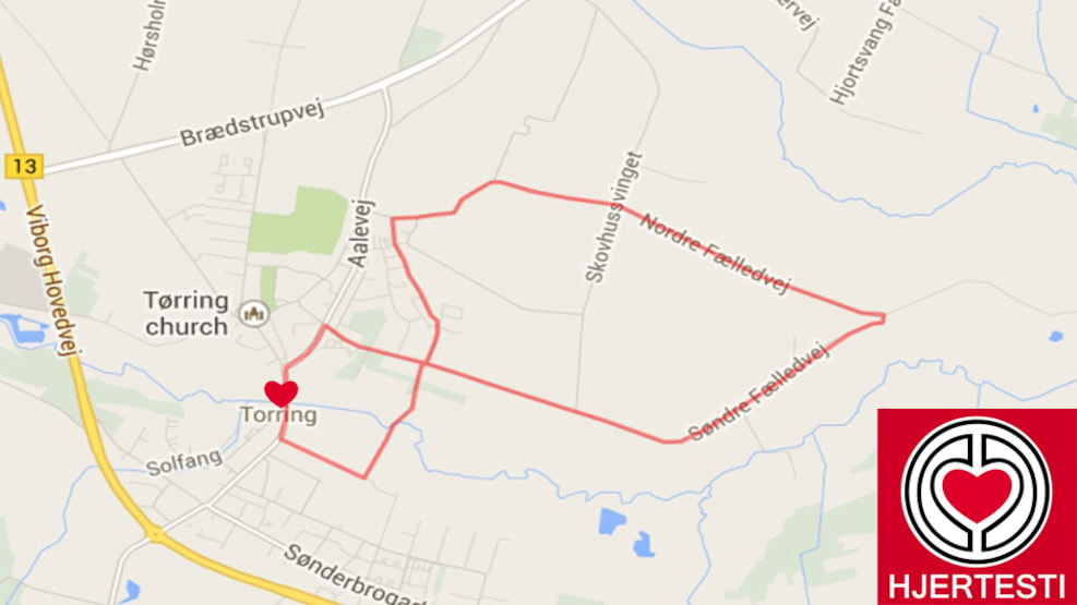
The heart trail is a roundtrip. Therefore, you can start your hike wherever you please. We suggest starting in Tørring though as there are plenty of parking spaces in the centre. This text is based on a start at Tørring Camping that has a café where you can grab a bite to eat and some refreshments before or after your hike.
Starting at the camp site you will cross the river Gudenå on Aagade, turn right on aalevej and again on Søndre Fælledvej. Follow this road for two kilometers as you make your way to a more open and increasingly wet landscape.
At one point Søndre Fælledvej will cross Nordre Fælledvej. This also marks the arrival to an area with an interestin name, the world’s end (Verdens Ende). If you follow the route, you will turn back towards town. You might want to continue heading east for a few hundred metres though, until you reach a picnic area. This is a good and peaceful place to enjoy your lunch at the banks of the Gudenå.
If you feel like walking even further, you can continue east to Uldum Kær where the nature is quite unique. Otherwise just make a 180-degree turn around and head back to Tørring on Nordre Fælledvej. Shortly before Nordre Fælledvej ends at a T-cross, you can turn onto a path and follow it for two kilometres until you reach Bredgade. From here you are very close to Aagade and Tørring Camping where you started.
Follow the route on a digital map
The route is waymarked with heart symbols on poles. You also have the option to follow the routes on your phone with a digital map. Follow this link to open the map (Google Maps).
Try The Gudenå Trail
The Heart Trail in Tørring shares part of its route with The Gudenå Trail. The Gudenå Trail takes you from the sources of the Gudenå in Denmark’s biggest oak scrub, Tinnet Krat through beautiful nature in the Gudenå Valley to Tørring and on to Uldum Marsh. This exceptionally scenic route stretches 174 kilometres and leads you through a varied landscape in the Gudenå Valley on its way to Randers Fjord.
About heart trails
Heart trails are waymarked hiking routes that make it easy for you to get exercise on workdays. The routes are typically found in cities and towns where people live. They are found all over Denmark.
The nearest other heart trails are found in Brædstrup, Hedensted, Nørre Snede, and Horsens.
Last updated on June 12, 2025 by Casper Terkelsen